


Near Schreiber
The power lines and water tower west of Scheiber are part of a hydropower generating system, taking advantage water in the Aguasabon River (which crosses the highway west of Terrace Bay) diverted into Lake Superior from Long Lac, formerly flowing northward into the Albany River system. By international agreement, since 1939 this water diversion scheme was constructed (along with another, into Lake Nipigon) to increase the Canadian allocation of water for hydroelectric power at Niagara Falls.
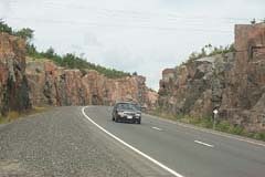
Rock cut just east of the Jackfish River
From the historic marker on the north side of the highway a steep-sided hill (cuesta) is visible. You can see alternating layers of red Sibley sandstone alternating with brick·red limestone and capped by a thick layer or “sill” of diabase, which is erosion-resistant. Fragments of Sibley have been found in the northern United States as a result of glacial movement. Below this stone Is another type of rock: granite. All three layers can be seen from a viewpoint 0.64 km east of here.

Rock Cut at Cavers Bay
At Cavers Bay a historic plaque describes the Precambrian Shield. A 4.5 m (13 ft) rock cut on the north side of the highway has some fine crystals of amethyst and fluorite. The veins in which they lie became exposed during rock blasting for highway construction. Amethyst, a semi-precious gem that is a clear purple or bluish violet variety of crystallized quartz. Fluorite is a transparent or translucent mineral in many colors, and is mostly calcium fluoride and is used in glass-making.
Other Highway improvements
Other work has been planned to upgrade the facilities of the Trans-Canada:
2016: rehabilitation of the Ozone Creek Bridge, replacement of the Gravel River Bridge, east of Nipigon, and the replacement of the Pic River Bridge, east of Marathon
2017: replacement of the Pays Plat River Bridges, east of Nipigon, the Prairie River Bridge east of Terrace Bay, and the White Lake Narrows Bridge, east of Marathon
2020: replacement of the Aguasabon River Bridge, near Terrace Bay
2021: Black Sturgeon River to Red Rock Four-lane widening
2019: West of Ouimet CPR Overhead to Dorion East Loop Four-lane widening
2020: 11/17 -Hwy 587 to Pearl Creek Four-lane widening
2018: 11/17 – 5.0 km west of Hwy 587 easterly Four-lane widening
Viewpoint west of Steel River
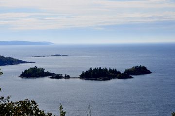 Just west of the Steel River there Is a good view of the Slate Islands in Lake Superior, on which there is a herd of about a hundred woodland caribou. On these islands the natural environment of the caribou has been disturbed logging operations and fire, just like on ‘the mainland by but the islands have no predators.
Neys Provincial Park
 Neys Provincial Park has low sand dunes of sand blown up from the shore of Lake Superior, which happened several thousand years ago, before there was an extensive cover of trees and other. The Ice Age glaciers pulled back 10,000 years ago, but vegetation does not appear immediately, and the thick boreal forest covering the area today took thousands of years. The park was used during World War II as a camp for German prisoners of war. In summer, park naturalists offer an Interpretive program.
On a clear day, travellers get a good view of the area by driving up a rough gravel road, away from the park for about 5 km to a microwave tower on the top of the hill. There, you can see the direction in which the glacial ice moved across the rock by comparing the rounded (stoss) side of the outcrop to the angular (lee) side, from which fragments were plucked away as the ice sheets scraped in that direction.
More Trans Canada Highway History
Trans Canada Highway Itinerary Map
Use mouse to drag/move map. Click on “+” or “–” to zoom in or out. “Satellite” combines map & photo.