This route connects Ontario’s important northern mining towns on a thousand kilometre drive across the Precambian Shield. See glacier-scoured rocks, thousands of lakes, and never-ending Boreal Forest. You get to see four of the most magnificent lakes in Canada: Lake Nipigon, Lake Superior, Rainy Lake, and Lake of the Woods. And in the southern portion, travellers can see Lake Simcoe and Lake Nippissing.
Trans-Canada Northern Route across Ontario Highway 11
The Quebec Portion of the Northern Route (AutoRoute 15, 117)
This Northern Route of the TransCanada runs from the island/city of Montrealinitially on AutoRoute 15or AutoRoute 117 through the Laurentians towns like Saint Jovite, Mont Treblant, and Mont Laurier. AutoRoute 117 runs from downtown Montreal, and meanders through many communities and has lots of traffic lights, but the 4-laned AutoRoute 15 is an expressway rough the North Shore Montreal suburbs into the Laurentian communities and runs up to Sainte Agathe-des-Monts. The route then continues on AutoRoute 117 north from the Laurentians through the LaVarendrye Wildlife Reserve into Northern Quebec. The Northern Route then continues into Canada’s “mining belt” with cities like Val d’Or. From there is contenues to Kirkland Lake via ontario Highway 66 , where it connects to Ontario’s Highway 11 and contines west past Hearstand Nipigon, where it joins the Trans-Canada main route to Thunder Bay.
North York-Yonge Street Condos
Yonge Street and Highway #11 “The Longest Street in the World”
Ontario’s Highway 11 has claimed to be “the longest street in the World” for starting at Toronto’s waterfront, running up Yonge Street through Barrie, Ontario’s cottage country (including Orillia, Huntsville, and Gravenhurst), to North Bay (where it crosses the Main Route of the Trans-Canada Highway). The Trans-Canada North continues to Kirkland Lake and arches around to Nipigon and Thunder Baybefore continuing west to Fort Frances and Rainy River (two towns on the US border with the state of Minnesota), for a total running length of 1,896 km, which Guinness Book of Records recognized Yonge St as the “Longest Street in the World”.
(1998 highway changes and relabelings between Torontoand Barrie may threaten that record).
Muskoka lodge on the water
Near-North Muskoka Cottage Country
The heart of Ontario’s cottage country runs through the Muskokas starting at Orillia (just west of Highway 400), and then in quick succession, the communities of Severn Bridge, Severn Bridge, Bracebridge, Huntsville, Burk’s Falls, South River, and Powassan to North Bay. As yo umake that drive you pass by the may scenic lakes, and from Huntsville a very good entrance into the scenic Algonquin Provincial Park.
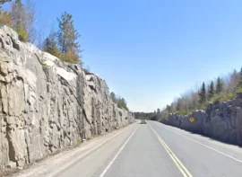
North Bay – Highway 11 North with rock cut
The Ontario Northern Route #11
The officially designated Northern Route begins where#11 crosses the Main Trans-Canada at North Bay. From this point the Northern Route arches abouve Lake Superior through a chain of northern Ontario mining towns, that because of their strategic importance to American(and Canadian) weapons manufacture during World War II were quickly conected by road.
Kirkland Lake from the air- Cover Photo
These towns were already connected by rail lines built in the late 1880s and early 1900s. These town include Temagami, Cobalt, Temiskaming Shores, Englehart,Kirkland Lake (where it connects to the Quebec Northern Route from Montreal and the Laurentians (introduced above), and then continues to Matheson, Iroquois Falls, Cochrane, Kapuskasing (today, best known for its wintertime cold-weather testing for the car manufacturers), and then Hearst, Longlac, Geraldton, Beardmore before bending sharply south to avoid Lake Nipigon and then crossing the Nipigon River into Nipigon.
Northern Route #11 near Hearst
Between Nipigonand Thunder Bay, the Main Route #17and the Northern Route #11 share the same roadway. It is currently being “twinned”. This began with the Thunder Bay Expressway, meant to bypass the urban areas of Thunder Bay to speed through traffic. The 4-lane Expressway arches around the west end of the city, and has since been continued east. The portion betwen Ouimet and the Dorion East Loop has recently been completed (2023), leaving about 35 km of the 110 km from Thunder Bay untwinned to Nipigon.
Fort Frances Ontario – view of Rainy River and Voyageurs National Park on the US side
The Rainy River Extension Highway #11
From Thunder Bay, travewllers can cotinue northwest on the #17 to Dryden and Kenora, or west of the #11 to Fort Francesand Rainy River (which now runs SOUTH of the Main Route). From Fort Frances, travellers head west a bit to Emo, and then head north on Highway 71 past Nestor Falls and Sioux Narrrows to reconnect with the main Trans-Canada Route #17 at Kenora. Highway #17 is 490 km between Kenora and THunder Bay, and the Highway 11 & 71 route is 560 km. Highway 11 continues west from Emo (junction with Highway 71) for another 50 km to the town of Rainy River, where there is a border crossing with Baudette, Minnesota.
This route along #11 was actually completed much earlier than the Highway 17 main route of the Trans-Canada. During World War II the strategic metals being mined in northern Ontario accelerated road-building (just like that war accelerated the construction of the Alaska Highway).
This northern route is much less travelled than #17, so travellers should heed “last gas for XX km” signs, and gas up at any major community they pass through
Map of Highway 11, the Northern Route of Trans-Canada in Ontario
NOTE:
Highway 11 Northern Route Itinerary Segments
Here are the segments of the Northern Route of the Trans-Canada Highway. We have set them up so that each segment’s start- and end-points are a population centre with traveller options for accommodation, gasoline (or battery recharging), shopping, things to do, and attractions.
 >
>