 The route from the NB-NS border to Cape Breton originally followed the route of what is now Trunk 4. The original Trunk 4 followed terrain curves for cost effectiveness, and connected and drove through the province’s established towns and cities, back when vehicle speeds were slower.
In many sections, that road has been superceded by a four-lane twinned expressway that has limited access and interchanges, travelling through more isolated and pastoral parts of the province (which makes land acquisition cheaper), and with much smoother curves and better road grading for higher speed. In 1997, the province opened the Cobequid Pass Toll Highway to bypass a meandering route through several small towns in rather hilly country.

From the inter-provincial border at Fort Lawrence, the highway runs east for 48 kilometres (30 mi) past the towns of Amherst and Oxford to Thomson Station. This section had been built in the 1960s as a 2-lane freeway, and was upgraded to a 4-lane divided freeway that opened in 1993. This section has a posted speed limit of 110 kilometres per hour.
The highway provides two places to connect to PEI, across the Northumberland Strait: at Pictou/New Glasgow you can catch the ferry, and from Cape Tourmantine, you can drive over the 22 kilometre long Confederation BridgeNew Glasgow
Heading north to Cape Breton

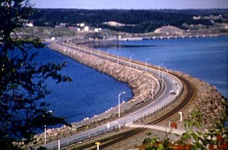
In 1955, following Newfoundland joining Confederation, the Canso Causeway was opened, to speed road and rail traffic to and from the new province, by cutting out one short ferry hop.
Once on Cape Breton and on your way to Newfoundland, travellers have three must-see attractions: the Alexander Graham Bell National Historic Site at Baddeck on beautiful Bras d’Or Lake, the re-built French Fortress of Louisbourg, and the stunning drive along the Cabot Trail (which was a Depression-era make-work project, opening in 1932).
Here are some history notes, organized by Itinerary Segment (from west to east):
Moncton, NB to Truro, Nova Scotia
Truro to New Glasow/Pictou
New Glasgow to North Sydney
Other Resources
Nova Scotia Map
![]() City
City
![]() Town
Town
![]() Itinerary
Itinerary
![]()
History
![]()
Ferry
![]() Tour
Tour


