Trans-Canada Highway.com please wait to load
What
image
  • imageAccommodations
  • imageAir Travel
  • imageAirport Parking
  • imageAttractions
  • imageAutomotive
  • imageBed & Breakfasts
  • imageBoat Rentals or Charters
  • imageBuses or Shuttles
  • imageCafe
  • imageCampgrounds
  • imageCasinos
  • imageCinema
  • imageCraft Beer - Winery
  • imageCurrency Exchange
  • imageEmergency
  • imageEntertainment
  • imageFarmers Market
  • imageFestivals
  • imageFire Hall
  • imageFirst Nation
  • imageFlea market
  • imageFree
  • imageGolf Course
  • imageGovernment
  • imageHistorical
  • imageHospital
  • imageHostel
  • imageHotels
  • imageKids Amusement
  • imageLimousines
  • imageLong Term Rental
  • imageMarijuana /CBD
  • imageMarinas
  • imageMuseum / Gallery
  • imagePark
  • imagePolice
  • imagePublic Transit
  • imageRental Car
  • imageRest Stops
  • imageRestaurant
  • imageRV Rental
  • imageShopping
  • imageShopping District
  • imageShopping mall
  • imageSki Resort
  • imageSpa
  • imageSports & Recreation
  • imageSports Team
  • imageTaxi
  • imageTheatre
  • imageTour
  • imageTourist Services
  • imageTours & Tour Guides
  • imageTrain
  • imageTransit Hub
  • imageTransportation
  • imageTravel
  • imageTravel Info/Office
  • imageVacation Rental
  • imageWilderness Lodge
Where
image
image

Crowsnest Pass, Alberta

View of Crowsnest Mountain

This area is named for the pass that lies below a mountain peak that resembles a giant crow’s nest. The pass crosses the Continental Divide and is the southern-most rail and road route from the prairies to the Pacific. The Crowsnest Pass area encompasses a number of communities along the Crowsnest Highway 3 on both sides of the Alberta – BC boundary. The towns in this area began their existence about a century ago as coal mining towns moving from Bellevue to Coleman, Frank, Hillcrest and in BC, Fernie.

Crowsnest Pass History

This region has been settled by the First Nations and their ancestors for over 10,000 years. A 1973 survey of the area identified 250 prehistoric sites. One 8500 year old summer camp was identified on the shores of Crowsnest Lake.

View of Frank Slide debris field, Crowsnest Pass

The area was first settled by Europeans in 1880s when a sawmill was built at Mill Creak, about 19 km south of the pass by Senator Peter MacLaren who moved her from Perth, Ontario. The construction and completion of the Crowsnest Pass railway in 1898 ensured its economic success. A new mill was built in Blairmore in 1900 which thrived until 1932. By that time coal deposits were found in the valley, and quickly became the main industry of the Crowsnest Pass. The five main communities in the Pass were all founded at the start of the 1900s to support the coal mines. Bellevue & Hillcrest (to the east of Frank Slide) and Blairmore & Coleman (between Frank and the BC border) have dozens of buildings dating back to this era.

Frank Slike Observation deck by Visitor Centre

The Frank Slide, which visitors first see on the south site of the highway, but soon realize it has spread to the north side of the road, where the Visitors Centre is placed. One April 29, 1903 over 60 town residents were killed when the south slope of Turtle Mountain released 90 million tones of limestone, burying the town, the railroad, and a mine. Turtle Mountain on the south side is 2,109 metres (6920 ft) tall and all the rocks in the valley come from a slab that was 150 metres (500 ft) deep by 425 me (1,400 ft) wide, which slipped off an unstable mountain in under two minutes.

The Hillcrest Mine Disaster struck on June 18, 1914 killed 189 coal miners (though some reports put the number at 195) and is the worst Canadian mining disaster of all time. A 9 foot monument was unveiled in the town cemetery in 2000, marking the mass grave for all but 6 of the lost miners (those were returned to their families in Nova Scotia to be buried with their families). Other mine disasters in the Pass occurred in 1910 (30 miners killed), and 1926 (10 killed).

During the Prohibition from 1916 to 1924, the area was popular with rum runners. The leader in the area was Blairmore merchant and one-time town councillor Emilio Picareiello, also known as Emperor Pic.

Town information about communities to the east along the #3 Crowsnest Highway includes Pincher Creek, Cardston, Fort MacLeod, Lethbridge, Medicine Hat, and Cypress Hills Inter-Provincial Park.
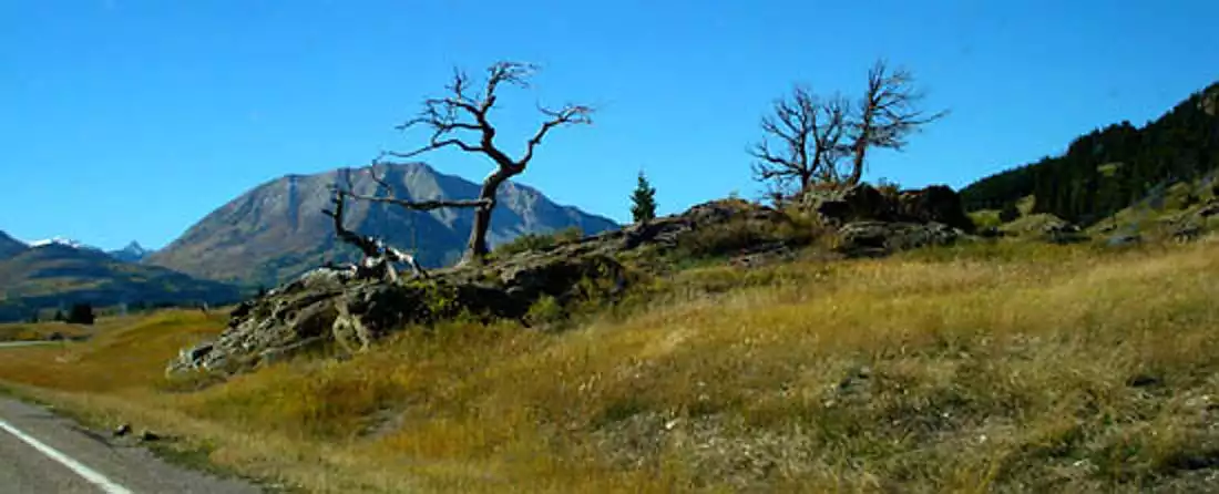
Crowsnest Pass Burmis Tree-sliver

Crowsnest Pass Attractions

Attractions are listed from east to west: from Lundbreck, to Burmis, to Bellevue & Hillcrest, Frank, Blairmore, Coleman until you reach Coleman Lake at the BC border, and then to Sparwood inside BC.

Burmis Tree*

Along Highway 3 near Highway 507, on the north side of the highway

The tree is named for the nearby town of Burmis. The unusual shape of the tree is caused by the strong winds in the Valley, making it a long-time popular stop for artists and photographers. The Burmis Tree was estimated to be between 600 and 750 years old. A highway straightening in 1971 was rerouted around the tree, and a small highway pullout was added for tourists and photographers (watch for a crow sculpture) The tree has been dead for a decade, but is still popular.

Leitch Collieries Provincial Historic Site*

Box 959, Crowsnest Pass, AB T0K 0E0
(15 km E of Blairmore on Hwy. 3)
(403) 562-7388

Leitch Collieries offers a self guided trail around the former mine site. Interpretive trails lead past the mine manager’s residence and coke ovens.. One of the most sophisticated early coal mining operations. Displays explain the coal extraction process used from 1907 to 1915, when the mine closed, unable to fund expansion necessary to meet First World War coal demand. Open year round. Summer interpreters lead guided tours from May to September. Admission fee.

The Bellevue Mine

2531 213 St, Bellevue, AB T0K 0C0
Mailing: CNP Ecomuseum Trust, Box 1740 Blairmore, AB T0I 0E0
406-564-4700 fax: 403-562-8634

Put on a miner’s helmet and lamp and follow the corridors taken by the coal miners as they worked this mine from 1903 to 1962. Walk underground through a portion of the old West Canadian Collieries mine. You will see a “room”, a coal chute and original mine artifacts while mine interpreters explain the techniques of underground mining. This 30 minute tour runs daily from 10:00 to the final tour at 5:30. You will find the 300 meter coal mine tour level and wide for easy walking (but dress warmly: the mine temperature is about 5C or 45F). The Bellevue Mine is accessed via the town’s business core. May 15 to Labour Day. Tours are coordinated through the Frank Slide Interpretive Centre at: (403) 564-4700 Admission fee.

Hillcrest Mine Disaster Memorial*

200 4 Ave, Hillcrest Mines, AB T0K 1C0
(403) 562-7388

The Hillcrest Mine Disaster struck on June 18, 1914 killed 189 coal miners and is the worst Canadian mining disaster of all time. A 9 foot monument was unveiled in the town cemetery in 2000, marking the mass grave for all but 6 of the lost miners (those were returned to their families in Nova Scotia to be buried with their families).

Frank Slide view

Frank Slide Interpretive Centre

1.5 km north of Hwy. 3 in Municipality of Crowsnest Pass
Ph:(403) 562-7388 Fax: (403) 562-8635 Toll Free in Alberta: 310-0000 then 562-7388

Displays illustrate the disastrous 1903 Frank Slide, railroad building, European settlement, early coal mining and community life. Dynamic multimedia presentations include the award-winning film, “In the Mountain’s Shadow”. Trails around the centre provide spectacular views. Open Summer (May 16 – Sept. 1), 9 am – 8 pm; winter, 10 am – 4 pm Allow 1 hour. Trails and scenic lookouts are free. Visitor centre admission fee.

The Crowsnest Art Gallery

14737 20 Ave, Frank, AB T0K 0M0
(in Frank, on north side of Highway #3)
(403) 562-2218

The building served as the Frank School and then Community Hall. Donations accepted. Open year round. The Art Gallery features exhibitions of local, provincial and national artists. Pub and Coffee nights, poetry readings, and a collection of Gushul Photos.

Crowsnest Pass – view of mountains just inside BC -sliver

Crowsnest Pass Museum

7701 18 Ave, Coleman (south side of Highway 3)
403-563-5434

Located at the former Coleman High School, this facility has both indoor and outdoor displays with 25,000 artifacts that reflect life & industry around the early settlement. Exhibits about the Hillcrest Mine Disaster, rum running across the border, and wildlife exhibits. Group tours, Picnic tables. Open may 20 – Sept 2 daily from 10 am to 6 pm; the rest of the year open weekdays only from 10 am to noon and 1 pm to 4 pm. Admission fee.

Allison Creek Brood Trout Station

3 km West of Coleman, 4 km N of #3 Highway on Allison Creek Rd.
(403) 563-3385

Brood stock station for brook, brown and rainbow trout eggs. Open year-round. Admission Free

Worlds Largest Truck

Sparwood, BC

One of the most sophisticated early coal mining operations. Displays explain the coal extraction process used from 1907 to 1915. Interpretive trails lead past the mine manager’s residence and coke ovens. Open year-round. Admission Free

Crowsnest Pass, Alberta Area Map