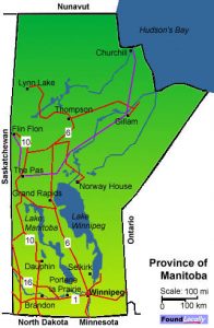
Manitoba began numbering its provincial trunk highways in 1926, and while the original highway 1 was one of nine highways fanning out from Winnipeg, but was different in that it fanned out both from the west and the east. The route of now-Highway 1 was routed via many already-existing highways and provincial secondary roads, and typically followed the surveyed east-west route of the trans-continental railroad, and by the early 1950s grew to be an important route for inter-provincial travel and trade.
Between 1958 and 1968, most of the provincial highways (including Highway 4) that formed this route were re-numbered and designated as the #1 and relocated to its present route. In 1962, the Trans-Canada Highway in Manitoba was fully completed, and Highway 1 across all of the western provinces was incorporated as part of the Trans-Canada Highway.

The route is now almost entirely twinned, including a ring road around Winnipeg, and bypasses around Portage la Prairie. The last portion to be twinned is the 18 kilometer stretch in the southeast corner of the province around Falcon Lake Provincial Park (and Ontario is looking to twin the stretch from the Manitoba border to Kenora)


