


This section of the TransCanada Highway # 104 was originally following the meandering 2-lane route of what is now Trunk 4, which was paved in the 1960s. Highway 104 ran right through the middle of New Glasgow. The new alignment of 4-lane divided freeway, which ran south of New Glasgow, was opened in the late 1990s.
The stretches east of New Glasgow were upgraded at various times, from the early 1990s into the 2010 as far as Sutherland River, with a 37 km long 2-lane stretch form there to close to South River Station, which has a 4-lane divided section for a 15 km stretch, before returning to and is a 2-lane freeway from that point to the western end of the Canso Causeway.
The 2-lane sections were built in the 1960s as an uncontrolled access highway (formerly Trunk 4) and have a posted speed limit of 70 km/h. Highway 104 ends at the Canso Causeway
McLennans Brook
This brook, just east of Stellarton,has cut through many layers of the blue-grey shale. Shale is created when clay settles on ocean floors and is compressed into rock, and its dark colour comes from “coal oil”. The rock is quarried today for making bricks.
Mainland Geology
Pictou Highlands are rolling hills of quartzite, late and lava and form the eastern extremity of the Cobequid Uplands. Here, the hills are fairly worn down, which exposes older and more interesting rocks. The hills east of New Glasgow are covered with hardwoods, and the temperature differences between hills and valleys show with different vegetation at different levels, notably with evergreens in valleybottoms. Farming here is limited by the frost-prone valleys.
An increased frequency of pulpwood trucks transporting timber indicates the presence of two nearby mills along the Canso Strait. The province has five pulp mills which absorb most of its cut timber. Before 1961, most of the trees were used in lumber mills, but pulpmills were able to consume wood that was unsuitable for lumber, as well as sawmill residues which ensures the forests are harvested and used efficiently. Balsam fir is grown in coastal lowlands, and two million trees a year are exported to US and Caribbean markets.
The Guysborough Bras d’Or Lowlands are low hills far enough away form the Atlantic to be warmer and dryer than coastal regions. The area was cleared and used by early settlers used for raising sheep. This area has lost much of its population since 1900.
The Canso Strait was an ancient river valley, and when the mile-thick ice from the last ice age retreated and the land began to rise up after being relieved of that heavy load, and as sea levels rose (from all that ice melting) the oceans moved in quickly to cover many areas formerly above sea level.
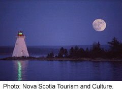
Canso Causeway
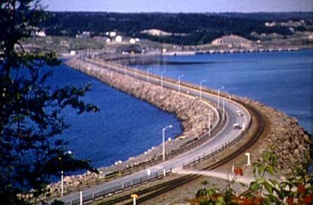
The Strait of Canso (which also is known by Gut of Canso or Canso Strait, and as Straits of Canceau or Canseaux until the early 20th century), is a strait that divides the Nova Scotia peninsula from Cape Breton Island.
Since 1819, ferries crossed the deep Strait (and in the railway age, connecting to a train on the other side), When Newfoundland joined Confederation, complicated communication and shipping to/from Newfoundland and needed to be eliminated. Canada built the Canso Causeway for vehicular and rail traffic, which opened in 1955.
The Canso Canal allows ships to pass through the causeway, and this can accommodate any St. Lawrence Seaway capable vessel, so they can continue up the St Lawrence using the Seaway completed in the late 1950s.
The uncontrolled access section from the eastern end of Auld’s Cove, the highway runs east for 2 kilometres (1.2 mi) across the Strait of Canso on the Canso Causeway to Port Hastings. This stretch has a railway track just to the south/ east side of the roadway, and was opened in 1955.
On the east side of the causeway, at Port Hastings, the speed limit is 70 km/h approaching a roundabout (traffic circle) connect Trunk 4, Trunk 19, Highway 104 and Highway 105. Highway 105 proceeds northeast carrying the Trans-Canada Highway designation toward North Sydney. Travelers can also continue on highway 104 east to St Peter’s (with its historic sea-level canal to Bras D’or Lake, or head all the way around the roundabout, and back west across the Canso Causeway on Highway 104.
Highway 105
 Highway 105, which has been so named wince 1970, follows the route of the former Trunk 5.
The highway travels northeast from Port Hastings along the base of a group of mountains known as “The Big Ridge” to Whycocomagh. It then follows the north shore of Bras d’Or Lake, bypassing Baddeck (which is served by #205) where the Alexander Graham Bell National Historical Site is located.
Then Highway 105 continues a northeast direction, at St. Anns the highway connects with the east side of the Cabot Trail before ascending (from about sea level) up the west slope of 250 metre Kelly’s Mountain on the Cape Dauphin Peninsula. It then descends the east slope of Kelly’s Mountain, passing Bras d’Or Lookout, and passes through a series of sharp turns including a 180° hairpin turn at New Harris Forks, before crossing the Great Bras d’Or Channel of Bras d’Or Lake (back to sea level) on the Seal Island Bridge.
The road crosses Boularderie Island and the road runs through the villages of Bras d’Or and Florence (with two traffic lights), with just 3 km (1.9 mi) to the Marine Atlantic ferry terminal in North Sydney, where travellers can continue to Newfoundland. One ferry (about a 6 hour voyage) runs year round to Port-aux-Basques on the southwest tip of the island, another ferry (about a 12 hour voyage) sails to Argentia on the eastern end of Newfoundland, closer to St John’s.
The Cabot Trail, which is usually used to describe a different road, is signed along a portion of Highway 105 between Nyanza and St. Anns so that the signed route forms a loop.
Highway 104 on Cape Breton
From the roundabout at Port Hastings, the highway follows the Cabot Strait for 12 kilometres (7.5 mi) along Trunk 4 through Port Hastings and the town of Port Hawkesbury. The speed limit is 50 km/h (31 mph) as there are many intersections controlled by traffic lights. Just north of Port Hawkesbury, Highway 104 magically reappears, at the Exit 43 interchange for Trunk 4 in Melville.
There have been proposals for a Highway 104 bypass from Port Hastings to Melville, with an alignment following a power line corridor to an electrical substation, alongside Highway 105.
From there, the highway is a controlled-access highway east for 34 kilometres (21 mi) to its current eastern terminus at an at-grade interchange with Trunk 4 in River Tillard (near St. Peters). This section was built in the 1970s and has a posted speed limit of 100 mp/h (62 mph).
An extension of Highway 104 from River Tillard to Sydney River has been proposed in the past.
Whycomagh
Whycocomagh, which is Micmac for “head of the waters”, is home to an Indian Reserve. Before Europeans came, the Micmac summered around Bas D’Or Lake to fish, hunt whales, collect shellfish, and collect seabird eggs and in the winter, headed inland to hunt bear and moose.
You can hike to the top of Salt Mountain in Whycocomagh Provincial Park. In the 1880s the town’s population rivaled Sydney’s population, though today the town has only 300 inhabitants.
Bras d’Or Lake
You now approach
Bas d’Or Lake
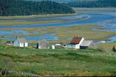
which became an inland sea when the Atlantic moved 160 km (100 miles) up from its old coastline nearer to Sable Island. The lake has a tidal range of only 18 inches, is great for saltwater sailing as well as fishing the introduced rainbow trout. The abundant fish stocks support a significant bald eagle population.
The
Middle River
delta into Bras d’Or Lake was built up from thousands of years of erosion in the highlands cerating rich soils, with a salt march at its edge. The older parts of the delta are now populated with water-tolerant shrubs and will eventually provide enough organic base to enable forests to grow.
Baddeck
is a forest service headquarters for the Cape Breton subdivision. In mid-channel look for tiny Toothbrush Island, which is a bird sanctuary and is home to a cormorant colony. Nearby is the Alexander Graham Bell National Historic Site.

Louisbourg
Louisbourg, names for King Louis of France, lies on the northeast corner of Cape Breton. The Fortress of Louisbourg here was built by the French to defend the mouth of the St Lawrence against the British, and be the first line of defence of Quebec City.
Interestingly, James Cook as a young British military surveyor and cartographer during the 1758 siege of Louisbourg, and was instrumental in mapping the fort and enabling the British guns to be optimally placed to bomb the Fortress into submission. During the 1970s, the ruins were excavated and the Fortress rebuilt., James Cook wend on to map and depth-sound the St Lawrence up and around Quebec City, marking the shallows for the British Navy which in 1759 was able to sneak past the Fortifications at Quebec on a moonless night, and to find a gully up the cliffs that the British could land and pull up cannons to the Plains of Abraham. This enabled British General Wolfe to fight and defeat the French commander, the Marquis de Montcalm in a one hour battle at that location (killing both commanders). After that, James Cook mapped Newfoundland (who’s maps were not improved upon until satellite mapping was possible in the 1960s), and was promoted to Captain and went on to explore the Pacific Ocean.
Cabot Trail

history of the Cabot Trail
The Cabot Trail is a highway and scenic roadway in northern Victoria County and Inverness County on Cape Breton Island in Nova Scotia, Canada. The route measures 298 km (185 mi) in length and completes a loop around the northern tip of the island, passing along and through the scenic Cape Breton Highlands.
North Sydney
From Highway 105 and the Ferry Docks, there is a ring road Route 125 around North Sydney, to provide better access to eastern Cape Breton and for tourism to Fortress Louisbourg. This route is also called Peacekeeper’s Way
By 2017, the route has been twinned all the way around to Grand Lake Rd, on the east side of the Sydney River, where it reverts to Trunk 4, which continues to Glace Bay. The second last exit take travelers to Louisbourg, the third last exit is for Trunk 4, back to St Peters and to Port Hastings on the Canso Strait.
Other Resources
More Trans-Canada Highway History
Trans-Canada Highway Itinerary Map
Use mouse to drag/move map. Click on ”
+
” or ”
–
” to zoom in or out. ”
Satellite
” combines map & photo.